


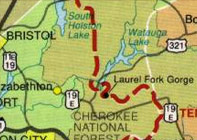
 The Appalachian Trail, known simply as the “A.T.” among those who hike on it, is a 2174.1 mile-long scenic mountaintop footpath used by thousands of backpackers each year to fellowship with wilderness and to commune with nature. The A.T. circles around Heartwood providing easy access to the trail off Walnut Mountain Road just 2 miles from the development. You could hike south for an overnight trip to Carvers Gap on top of Roan Mountain State Park or north for a one day hike to Dennis Cove. To make it an overnight trip continue over the Watauga Dam along the Iron Mountain Range into Damascus, VA. Check trail maps for mileage and levels of difficulty before planning your hike on the A.T.
For more information visit:
http://www.trailplace.com/
http://www.fred.net/kathy/at.html
http://www.rhodesmill.org/thefox/maps.html